Tornado Outbreak Possible today.
-
Big_Mirg_ZHS
 There is the possibility of a tornado outbreak across our area of the midwest today. Dr Forbes says there is a 7-10 chance of a tornado within 50 miles of anywhere from I-70 north in ohio. ANy storm chaser worth a damn is heading towards the are for tomorrow. Be sure to keep an eye on the skies tomorrow.
 -
coyotes22
 I seen this earlier.
The wife is freaking.
Im hoping we finally get a GREAT storm!!! -
killdeer
 tornadoes suck!
 -
Chesapeake
 <object width="480" height="385"><param name="movie" value=" name="allowFullScreen" value="true"></param><param name="allowscriptaccess" value="always"></param><embed src="" type="application/x-shockwave-flash" allowscriptaccess="always" allowfullscreen="true" width="480" height="385"></embed></object>
 -
dwccrew
 Better than a Herpes outbreak.
 -
sonofsam
 Where are they predicting? Western, central, or eastern Ohio?
 -
ts1227

Northwest and North-Central Ohio.sonofsam wrote: Where are they predicting? Western, central, or eastern Ohio?
I'm waiting for the updated outlooks from the SPC to be posted soon, then I'll post some maps. -
sonofsam

You have a site where this info came from?ts1227 wrote:
Northwest and North-Central Ohio.sonofsam wrote: Where are they predicting? Western, central, or eastern Ohio?
I'm waiting for the updated outlooks from the SPC to be posted soon, then I'll post some maps. -
ts1227

-
ts1227

FYI: Forbes' little index is complete and total bullshit.Big_Mirg_ZHS wrote: There is the possibility of a tornado outbreak across our area of the midwest today. Dr Forbes says there is a 7-10 chance of a tornado within 50 miles of anywhere from I-70 north in ohio. ANy storm chaser worth a damn is heading towards the are for tomorrow. Be sure to keep an eye on the skies tomorrow.
Best bet is to follow the Storm Prediction Center. They're not prefect, but Forbes' TOR:CON is complete bullshit meant to boost ratings in TWC.
The meteorology undergrads here have a pretty strong interest in severe wx, and have been keeping track of all of this stuff. It's pretty much a consensus that Forbes' thing is a media grab that blows cock. -
slide22K for you weather nuts... have an outdoor event in Bloomington, Indiana tomorrow night, whats the likelihood of rain? lol
-
lhslep134I hope I don't hit anything nasty driving back to Youngstown from Columbus tomorrow night.
-
majorspark
 Growing up we had a couple of tornadoes touch down less than ten miles from our house. I remember my Dad driving us out when we were kids to look at the damage. After that my brother and I were scared shitless of the things. We ended up in the cellar quite a few times when sever storm hit.
 -
sonofsam

There is a chance it may rain. If it doesn't rain, it will remain sunny to mostly cloudy. We will not top our record temp nor defeat our record low. Things should be pretty much right in the middle give or take a little bit.slide22 wrote: K for you weather nuts... have an outdoor event in Bloomington, Indiana tomorrow night, whats the likelihood of rain? lol -
ts1227
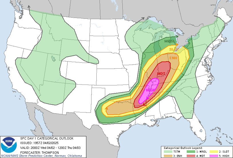
 Northern Ohio under a MODERATE RISK (this is serious business... anything past a slight risk = shit is going down)

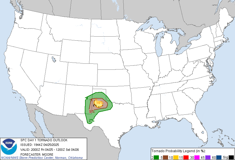
Tornado risk

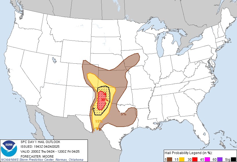
Severe hail (1" diameter or above) risk:

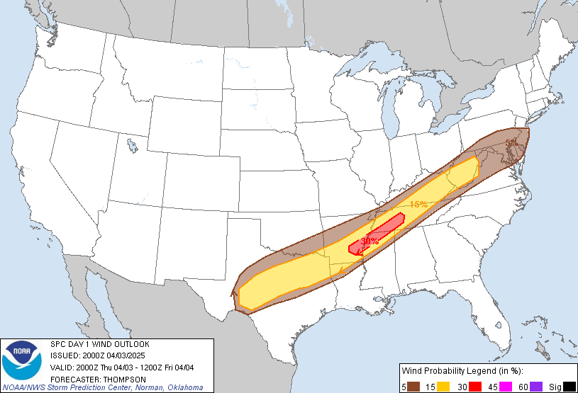
Severe wind (58 MPH+ wind) risk:

-
ttocs14

sawcoyotes22 wrote: I seen this earlier.
The wife is freaking.
Im hoping we finally get a GREAT storm!!! -
sonofsam
 I'm just outside ALL those graphics
 -
sonofsam
 ...OH VALLEY/LOWER GREAT LAKES...
00Z NAM/GFS GUIDANCE IS IN REASONABLE AGREEMENT WITH SPEED/MOVEMENT
OF MID LEVEL TROUGH AND ASSOCIATED H5 SPEED MAX ACROSS THE MID MS
VALLEY INTO THE OH VALLEY DURING THE LATTER HALF OF THE PERIOD.
THIS FEATURE WILL FORCE CNTRL PLAINS SFC LOW TO A POSITION JUST
SOUTH OF CHI OVER ECNTRL IL AT 18Z...THEN DEEPENING IS EXPECTED AS
THE CYCLONE LIFTS NEWD INTO LOWER MI DURING THE EVENING HOURS.
ALTHOUGH BOUNDARY LAYER MOISTURE IS SOMEWHAT LIMITED ACROSS THE
CNTRL/SRN CONUS EARLY THIS MORNING...A MODIFIED MOIST PLUME HAS
RETURNED ACROSS THE SRN PLAINS/LOWER MS VALLEY AND THIS AIRMASS
SHOULD EASILY RETURN TO THE OH VALLEY DUE TO STRENGTHENING LOW
PRESSURE SYSTEM AND INCREASINGLY CONVERGENT FLOW REGIME. NAM...IN
PARTICULAR...SUGGESTS THE CYCLONE WILL DEEPEN SIGNIFICANTLY AS SPEED
MAX INCREASES TO AROUND 110KT BY THE END OF THE PERIOD OVER
OH...WITH INTENSE 12HR HEIGHT FALLS INCREASING TO 240-300M.
NEEDLESS TO SAY VERY STRONG FLOW AND SUBSTANTIAL VERTICAL SHEAR WILL
EXIST ACROSS THE OH VALLEY ALONG THE RETREATING WARM FRONT AND
ACROSS MUCH OF THE WARM SECTOR PRIOR TO SEVERE CONVECTIVE
DEVELOPMENT.
I HATE it when there is REASONABLE AGREEMENT WITH SPEED/MOVEMENT
OF MID LEVEL TROUGH AND ASSOCIATED H5 SPEED MAX ACROSS THE MID MS
VALLEY INTO THE OH VALLEY DURING THE LATTER HALF OF THE PERIOD.
-
ts1227

Yous should be worrying more aboutsonofsam wrote: I HATE it when there is REASONABLE AGREEMENT WITH SPEED/MOVEMENT
OF MID LEVEL TROUGH AND ASSOCIATED H5 SPEED MAX ACROSS THE MID MS
VALLEY INTO THE OH VALLEY DURING THE LATTER HALF OF THE PERIOD.
CYCLONE WILL DEEPEN SIGNIFICANTLY AS SPEED MAX INCREASES TO AROUND 110KT BY THE END OF THE PERIOD OVER OH...WITH INTENSE 12HR HEIGHT FALLS INCREASING TO 240-300M. NEEDLESS TO SAY VERY STRONG FLOW AND SUBSTANTIAL VERTICAL SHEAR WILL EXIST ACROSS THE OH VALLEY ALONG THE RETREATING WARM FRONT AND ACROSS MUCH OF THE WARM SECTOR PRIOR TO SEVERE CONVECTIVE DEVELOPMENT.
The stuff you posted just says the models are all saying it'll show up at the same time.
Now my stuff... Strong upper level winds, pressure level height falls, shear = severe storms.
Trust me, I have a meteorology degree -
sonofsam

Yes, I hate 110KT and 200-300M[/b], I have no idea what it means, but it sounds intense.ts1227 wrote:
Yous should be worrying more aboutsonofsam wrote: I HATE it when there is REASONABLE AGREEMENT WITH SPEED/MOVEMENT
OF MID LEVEL TROUGH AND ASSOCIATED H5 SPEED MAX ACROSS THE MID MS
VALLEY INTO THE OH VALLEY DURING THE LATTER HALF OF THE PERIOD.
CYCLONE WILL DEEPEN SIGNIFICANTLY AS SPEED MAX INCREASES TO AROUND 110KT BY THE END OF THE PERIOD OVER OH...WITH INTENSE 12HR HEIGHT FALLS INCREASING TO 240-300M. NEEDLESS TO SAY VERY STRONG FLOW AND SUBSTANTIAL VERTICAL SHEAR WILL EXIST ACROSS THE OH VALLEY ALONG THE RETREATING WARM FRONT AND ACROSS MUCH OF THE WARM SECTOR PRIOR TO SEVERE CONVECTIVE DEVELOPMENT.
The stuff you posted just says the models are all saying it'll show up at the same time.
Now my stuff... Strong upper level winds, pressure level height falls, shear = severe storms.
Trust me, I have a meteorology degree -
said_aouita
 Xenia is fucked.
 -
Shane FalcoSo your one of those guys that never has to be right and still get to keep your job.
-
SnotBubbles
Ha! Kind of harsh, but funny!said_aouita wrote: Xenia is fucked.
I'm right in the middle of all of that. I'll give you guys updates throughout the day. Right now, very calm and storm clouds to the West. -
THE4RINGZ
 I am inside the circle on all those graphics. Looks like a fun night here.
 -
fortfanI live right in the middle of all that too. Van Wert seems to garner a lot of action lately. (I live south of Van Wert in Mercer County)


